Our Services
What can we do for you?
First off, what we don't do: we don't publish trail maps that you can buy in your local outdoors store. We also don't produce yet another general trails app. In many places of the West, other companies have done those things and are doing them quite well.
We primarily work with governments, land managers, planning consultants, engineers, and trail builders to create geospatial data, analysis, plans, and maps that will help them better serve and inform their trail user communities. The services that we provide help to create better trails, and help your hikers, runners, and riders enjoy your trails responsibly and safely.
Wall Maps
 Large maps can beautifully show off your trails network and their surrounding landscape, whether to decorate your walls or your fans. We have won several cartographic design awards for our wall maps.
Paper Maps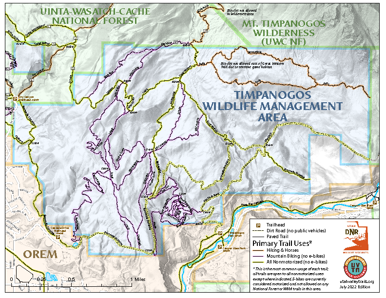
Sometimes the best way to inform your community is the traditional paper map, whether that is a simple free handout, an atlas-style booklet, or a professionally printed map with advertisements and/or interpretive information.
Web Maps
In today's world, web and mobile maps are the most popular way for your community to get detailed information, especially while they are on the trail. We have been doing web mapping since its earliest days (1994), and have produced many trails-oriented maps for trail planning (including collecting public comments and ideas) and trail use.
Trailhead Kiosks
Probably the most useful trail maps are those found at trailheads, where users can plan their trips while they are looking at the landscape. These are also the best place to educate visitors about the landscape they are about to visit and to remind them of proper trail etiquette.
Trails Data
We can collect detailed geospatial data on existing trails in your community, whether as part of any of these map products, or as its own product. We can also use these datasets to manage your trails in the several popular trails mapping websites and mobile apps to make sure they are delivering the most correct information to your trail users.
Trail Design and Planning
We have performed several trail planning projects, from the detailed routing of single trails to the community-based design of large network master plans. Our extensive GIS skills are especially useful in this process. We have worked with federal land management agencies to facilitate the NEPA approval process when necessary.
We perform these services in a professional manner and will do whatever is needed to meet your exacting quality standards. Contracted work typically covers consultation, data collection, design, and working with you on drafts, using our competitive hourly rates. Generally, you will own the copyright on all delivered products.